
Urban Metrics in UrbanAna: Real-time Project Analysis
Analyze urban metrics in UrbanAna. Use the Report tab for real-time data, pin metrics in the viewport, and export comprehensive reports to Excel for project, block, and building levels.
Knowledge Base
Report tab is used to review current Urban Metrics of project. Data is refreshed in real time, so any changes made to the model are instantly reflected.
Pin Metrics
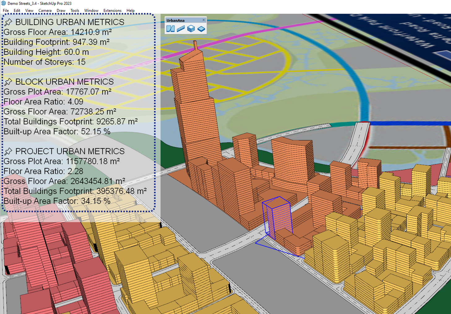
Pin metrics feature displaying key urban data directly in the viewport
The Pin Metrics feature allows you to display selected urban metrics directly in the SketchUp viewport. All data displayed is refreshed in real time, so any changes made to the model are instantly reflected. There are three Quick pin buttons corresponding to different object types:
- Project Pin: Toggle Pin project-level metrics like total Gross Floor Area, Floor Area Ratio, etc.
- Block Pin: Toggle Pin block-level metrics such as Gross Plot Area, Total Buildings Footprint, etc.
- Building Pin: Toggle Pin building-specific metrics like Building Height, Number of Stories, etc.
You can manually add or remove individual metrics by clicking the pin icon next to specific metrics you want to display/hide. For block and building-level metrics, you must first select the corresponding block or building object in the viewport before opening Report to pin their specific metrics.
The number in parentheses (0) shows next to each pin button show the current number of pinned metrics for that object type.
Urban Metrics – Project
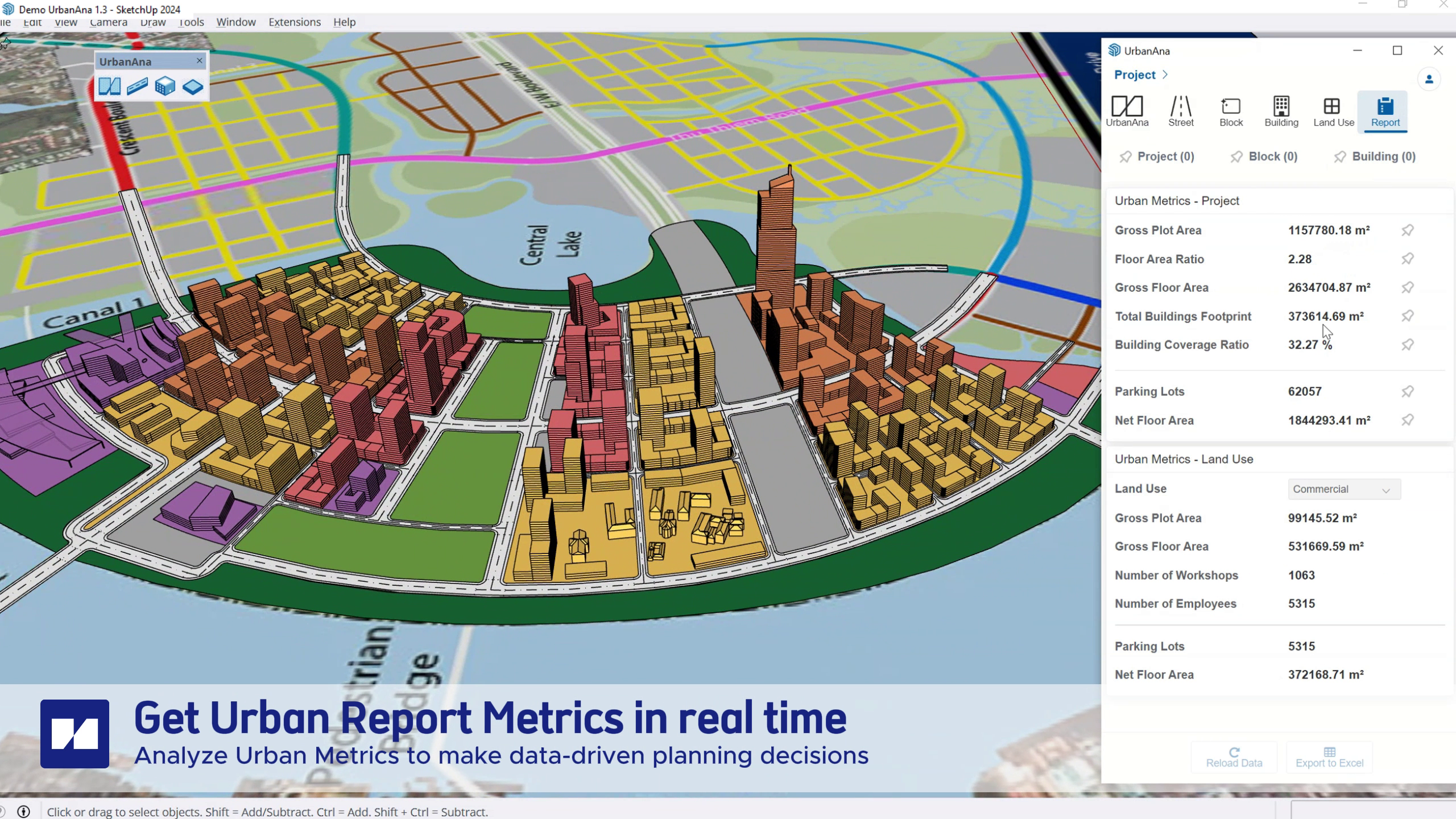
Urban metrics dashboard showing key development statistics and calculations
The Project metrics section displays key urban development metrics at the project level:
Gross Plot Area
Total land area of the development site, calculated by summing all blocks’ plot areas.
Floor Area Ratio (FAR)
Also known as Floor Space Index (FSI), this is the ratio of total gross floor area to the gross plot area. Calculated as: FAR = Gross Floor Area / Gross Plot Area
Gross Floor Area (GFA)
Sum of all gross floor areas of all buildings in the project.
Total Buildings Footprint
Sum of the ground floor areas of all buildings that are located within blocks. Used to calculate building coverage ratio. For Project level, buildings not placed on blocks are excluded from this calculation.
Building Coverage Ratio (BCR)
Also known as lot coverage, this is the percentage of the gross plot area covered by building footprints. Calculated as: BCR = Total Buildings Footprint / Gross Plot Area × 100%
Parking Lots
Total number of parking spaces required based on the land use parameters and parking requirements defined for each building. The calculation uses the parking ratios (GFA per Parking Space, Parking Lots per Primary Unit, Secondary Unit per Parking Lot) specified in the Land Use settings.
Net Floor Area (NFA)
Estimated net usable floor area calculated by applying the NFA Factor ratio defined in Land Use settings to each building’s Gross Floor Area. The NFA Factor represents the percentage of GFA that is typically usable internal space after accounting for walls, circulation, and service areas.
Urban Control – Land Use
This section displays metrics broken down by land use type. Use the Land Use dropdown to select and view metrics for a specific land use:
Land Use Selection
A dropdown menu allows you to filter metrics for a specific land use type (e.g., Residential, Commercial, Shophouse etc.). The metrics will update automatically when a different land use is selected.
Land Use Metrics
For the selected land use type, the following metrics are displayed:
- Gross Plot Area
- Gross Floor Area
- Parking Lots
- Net Floor Area
For detailed explanations of these metrics, see the Urban Metrics – Project section above.
Additional Land Use Metrics
- Number of Primary Units: Total count of primary units (e.g., apartments, offices) based on the GFA per Primary Unit ratio defined in Land Use settings
- Number of Secondary Units: Total count of secondary units (e.g., residents, employees) calculated using the Secondary Units per Primary Unit ratio
Urban Control – Block
When a block is selected in the viewport, this section displays metrics specific to that block:
- Gross Plot Area
- Floor Area Ratio (FAR)
- Gross Floor Area
- Total Buildings Footprint
- Building Coverage Ratio (BCR)
For detailed explanations of these metrics, see the Urban Metrics – Project section above.
Urban Metrics – Building
When a building is selected in the viewport, this section displays metrics specific to that building:
- Gross Floor Area
- Building Footprint
- Building Height
- Number of Storeys
- Parking Lots
- Net Floor Area
- Building Volume
For detailed explanations of these metrics, see the Urban Metrics – Project section above.
Report Tools (Tool section)
Reload Data
Regenerates and recalculates all urban metrics in the report. Use this if you notice any errors or inconsistencies in the data. The reload process will:
- Refresh all project-level metrics
- Update land use calculations
- Recalculate block and building-specific metrics
Export to Excel
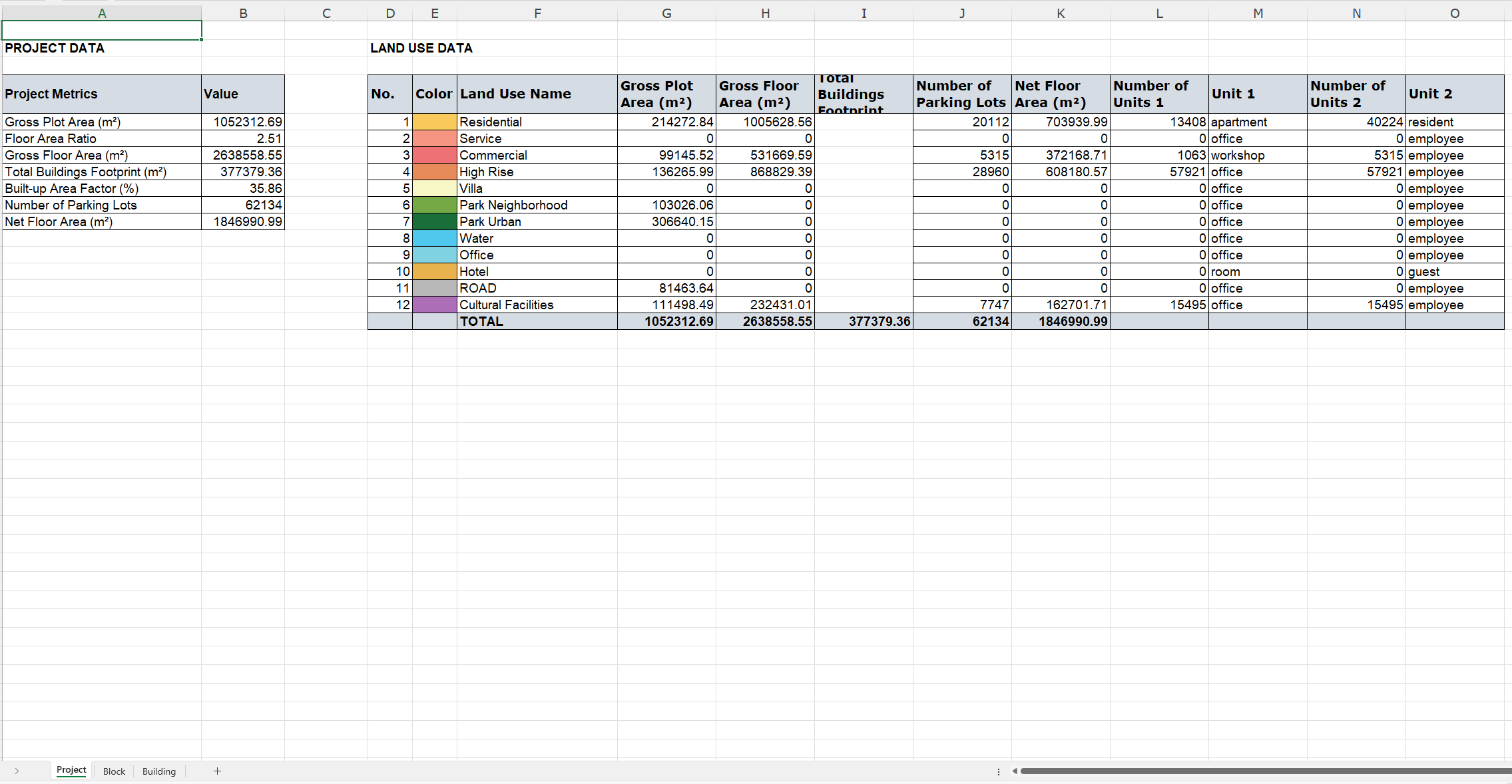
Excel export for comprehensive urban data reporting
Exports the current urban metrics report to an Excel file (.xlsx format). The exported file will include:
- All project-level metrics
- Metrics broken down by land use type
- Block-specific metrics for all blocks
- Building-specific metrics for all buildings
The Excel file will be organized into separate worksheets for each metric category, making it easy to analyze and share the data. To export:
- Click the “Export to Excel” button in the Report Tools section
- Choose a save location and filename
- The Excel file will be generated with all current metrics
In this article